


DJI Matrice 4E Precision Mapping & Surveying Bundle
- Regular price
-
$10,149.00 - Regular price
-
- Sale price
-
$10,149.00
Delivers in 5-7 Business Days
Net 30 Available for Agencies
Protection Coverage Available at Checkout
Couldn't load pickup availability
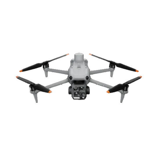
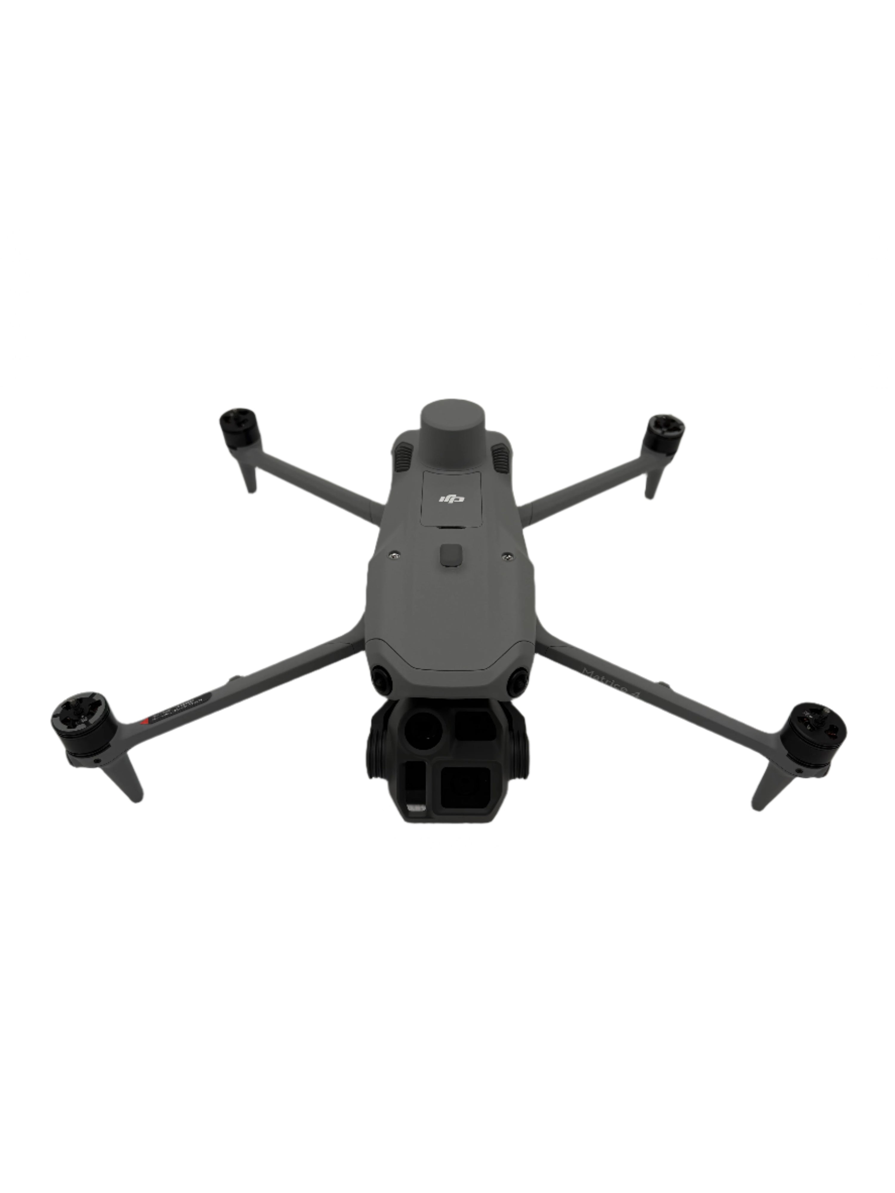

The DJI Matrice 4E Precision Mapping & Surveying Bundle is a complete aerial survey system for licensed surveyors, civil engineers, GIS professionals, and construction operators who need centimeter-accurate geospatial data and a workflow that produces deliverables your clients and regulators accept.
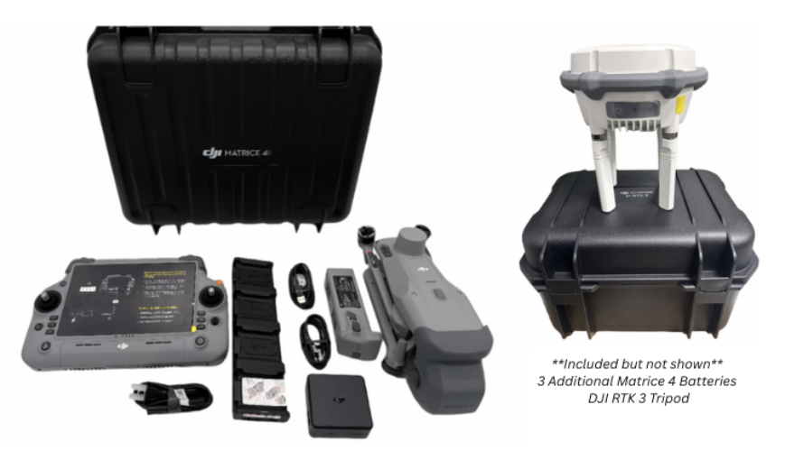
Aircraft, controller, four batteries, D-RTK 3 base station, survey pole and tripod kit, storage case, and a pre-activated 1-year DJI Terra license ship together in one order. Configured and ready to fly a survey-grade mission on day one.
The M4E's 4/3-inch CMOS wide-angle camera with mechanical shutter eliminates rolling shutter distortion at 21 m/s mapping speed. The D-RTK 3 base station delivers RTK Fix accuracy at 1 cm + 1 ppm horizontal, independent of cellular coverage, independent of NTRIP service availability, independent of anything that isn't in the case you're carrying to the site.
We've been equipping professional operators since 2017. Real people answer the phone at (863) 224-6923.
Standard delivery is 5 to 7 business days. Net 30 available for qualified buyers.
Quick Facts
- Built for: Licensed surveyors, civil engineers, construction operators, GIS firms
- Wide Camera: 4/3" CMOS with mechanical shutter, 20MP
- Cameras: 5 sensors (wide + 2 telephoto + laser rangefinder + thermal-less)
- RTK Accuracy: 1 cm + 1 ppm horizontal with D-RTK 3 base station
- Mapping Speed: Up to 21 m/s with mechanical shutter
- Flight Time: Up to 49 minutes per battery (4 batteries included)
- Oblique Capture: 5-directional in a single pass
- Coverage: Up to 2.8 km² per flight at standard altitude
- Processing: 1-year DJI Terra license included (approximately $1,400 value)
- Delivery: 5 to 7 business days
- Coverage: CPS Drone Protection available at checkout
What's in the Bundle
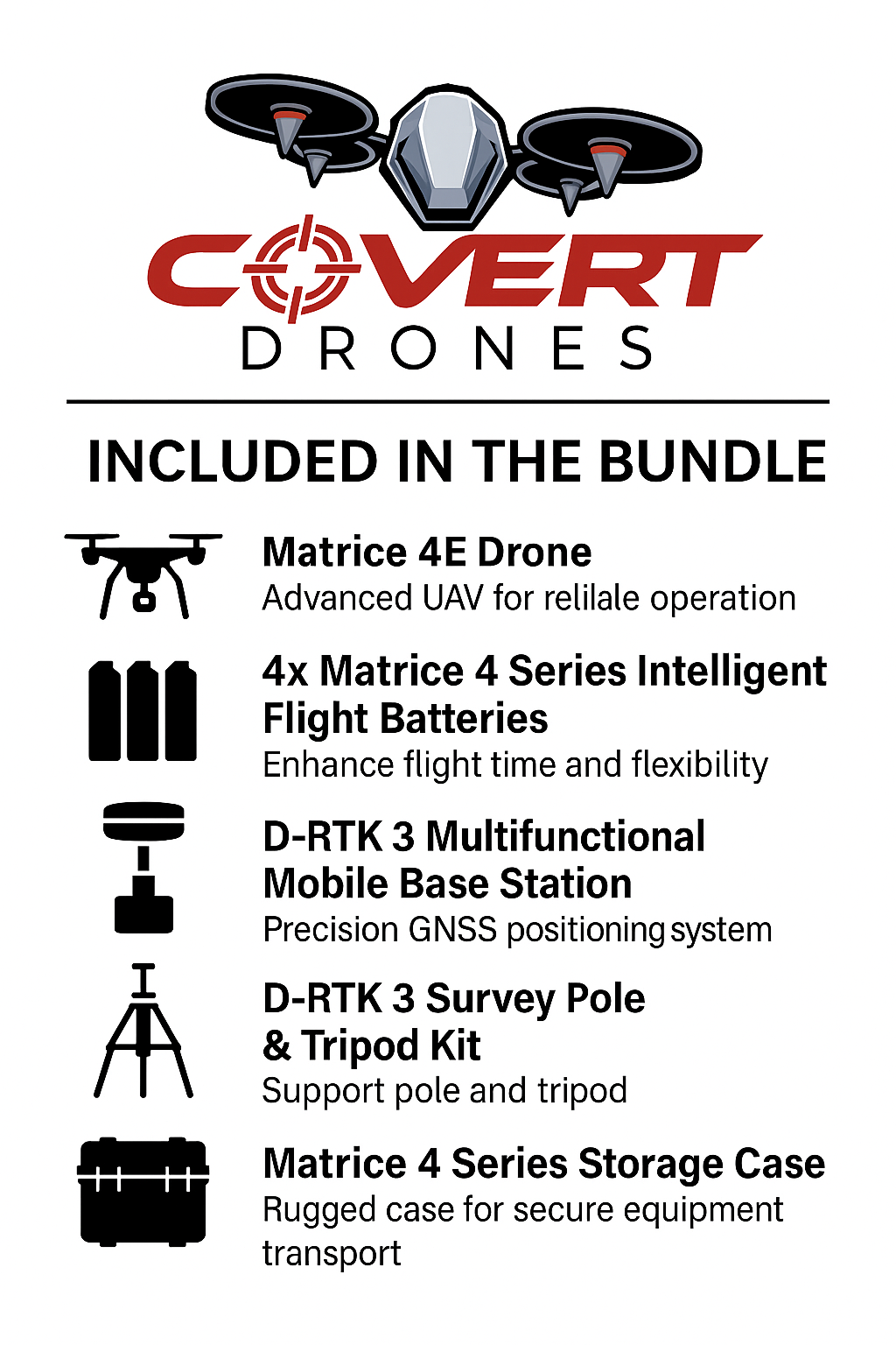
- DJI Matrice 4E Aircraft with 4/3-inch CMOS 20MP wide-angle camera with mechanical shutter, 48MP medium telephoto (70mm), 48MP telephoto (168mm, 112x hybrid zoom), laser rangefinder, integrated RTK module, omnidirectional obstacle avoidance, and 49-minute flight time
- DJI RC Plus 2 Enterprise Controller with 7-inch 1400-nit sunlight-readable display, DJI O4 Enterprise + 4G hybrid transmission, runs DJI Pilot 2 with autonomous route planning, Smart 3D Capture, and real-time survey quality reporting
- 4x DJI Matrice 4 Series Flight Batteries for up to 3.2 hours of total operational time with hot-swap rotations
- DJI D-RTK 3 Multifunctional Station with centimeter-level RTK Fix positioning (1 cm + 1 ppm horizontal, 1.5 cm + 1 ppm vertical), L5 frequency band support, and signal relay capability for extended range in challenging terrain
- D-RTK 2 Survey Pole and Tripod Kit with carbon fiber survey pole, adjustable-leg field tripod with leveling system, and carry bag for on-site GCP marking and benchmark setup
- DJI Matrice 4 Series Charging Hub and 100W USB-C Power Adapter
- RC Plus 2 Strap and Waist Support Kit
- 3 Pairs DJI Matrice 4 Series Propellers, gimbal protector, cables, 64GB microSD card
- DJI Matrice 4 Series Storage Case with shoulder strap, custom foam, full kit fits including controller
- 1-Year DJI Terra License (pre-activated) with approximately $1,400 retail value, included. Must be activated before shipping using your DJI account. See the Terra section below.
Have questions before ordering? Call us at (863) 224-6923 or email sales@covertdrones.com for same-day answers.
Important: DJI Terra License Activation
This bundle includes a 1-year DJI Terra license at no additional charge. DJI Terra is the photogrammetry software that processes your aerial imagery into orthomosaics, digital elevation models, point clouds, and 3D mesh models. The retail price of a Terra standard license is approximately $1,400 per year, so its inclusion here is a substantial part of the bundle's value.
DJI requires the license to be activated and tied to a specific DJI account before the drone ships. We handle the activation on your behalf at the time of fulfillment.
To include the Terra license, we need your DJI account email address when you place the order. Call us at (863) 224-6923 or email sales@covertdrones.com immediately after ordering and we'll take care of it before it ships. If you don't provide your account information, the drone ships without the Terra license and you would need to purchase it separately through DJI.
Terra License Renewal After Year One
The included Terra license is valid for 12 months from the activation date. After that, processing requires either a renewed Terra annual license, a Terra perpetual license, or a third-party photogrammetry platform like Pix4D or Agisoft Metashape.
DJI offers both annual subscription and perpetual licensing options for Terra. The annual subscription is approximately $1,400 per year, and the perpetual license is a one-time purchase at a higher upfront cost. For full-time survey operators running continuous workflows, the perpetual license typically pays for itself within 2 to 3 years versus annual renewal.
If you prefer to migrate to a different photogrammetry platform after year one, M4E imagery is fully compatible with Pix4D, Agisoft Metashape, DroneDeploy, Correlator3D, and Bentley ContextCapture. Your captured data remains usable in any of those platforms, with or without an active Terra license.
We'll send a renewal reminder approximately 30 days before your Terra license expires. Call us before then if you want to discuss renewal options.
Who This Bundle Is Built For
This is a professional-grade survey system, not a starter mapping kit. The D-RTK 3 base station, survey pole, and 4-battery configuration are designed for operators running production photogrammetry workflows where the data has to be right and a re-fly is not acceptable. The right buyers for this bundle are:
- Licensed professional land surveyors (PLS) incorporating aerial data collection into topographic survey, boundary reconnaissance, and parcel mapping workflows with legally defensible accuracy
- Civil engineering and AEC firms generating design-grade topographic data, as-built documentation, earthwork volume verification, and site progress models for construction administration
- Construction companies and general contractors running weekly stockpile volume surveys, cut-and-fill earthwork verification, and progress documentation across active job sites
- Mining and quarry operators conducting high-frequency volumetric surveys of overburden, ore stockpiles, and extraction faces for inventory reporting and regulatory compliance
- GIS and geospatial services firms adding drone-based data collection to their service offerings for municipal, infrastructure, and environmental clients
- Government and transportation agencies collecting corridor topography for road design, drainage analysis, and infrastructure assessment projects
- Environmental and natural resource consultants mapping watersheds, wetlands, and vegetation change for permitting, mitigation monitoring, and conservation planning
If you're evaluating the aircraft-only M4E without the RTK base station, see the DJI Matrice 4E standalone listing. Network RTK via NTRIP works well in areas with consistent cellular coverage. If your projects are in areas with reliable network coverage and you already have an RTK subscription, the aircraft-only configuration may be sufficient. If you're working in rural corridors, remote terrain, or anywhere cellular coverage is unreliable, the D-RTK 3 base station in this bundle is what delivers consistent centimeter accuracy regardless of network conditions.
Note on Survey Certification
The M4E is a data collection platform, not a certification tool. The drone captures imagery and position data with centimeter-level accuracy when used correctly with RTK corrections. Official survey deliverables (boundary surveys, ALTA/NSPS surveys, certified topographic surveys) require review and certification by a licensed professional land surveyor (PLS) in the jurisdiction where the work is performed.
The M4E provides the data. The surveyor provides the certification. For commercial deliverables that don't require PLS certification (construction stockpile volumes, progress documentation, asset mapping, GIS data collection), the M4E with the D-RTK 3 produces output that meets typical accuracy requirements directly.
Why the Matrice 4E Outperforms Other Compact Mapping Drones
Mechanical Shutter, the Detail Most Buyers Miss
The single most important feature separating the DJI Matrice 4E from other compact enterprise drones for photogrammetry work is the mechanical shutter on the wide-angle camera. Electronic-only shutters expose each row of the sensor sequentially rather than capturing the entire frame simultaneously. At mapping speeds of 15 to 21 m/s, that sequential exposure creates geometric distortion across the image. Straight lines appear curved, buildings lean, and the orthomosaic requires significant correction work or produces measurable errors.
The M4E's 4/3-inch wide-angle camera uses a true mechanical shutter that exposes all pixels simultaneously regardless of aircraft speed. The output is geometrically clean at full mapping speed, every frame, without post-processing compensation.
This is why the M4E produces better orthomosaics than the DJI Mavic 3 Enterprise, the DJI Air 3, and any other folding drone with an electronic-only shutter, and why licensed surveyors specify it over those platforms.
4/3-Inch CMOS, More Sensor, Better Data
The wide-angle camera uses a 4/3-inch CMOS sensor, significantly larger than the 1/1.3-inch sensor in the M4T or the sensors in consumer-grade mapping drones. A larger sensor collects more light per pixel, produces less noise at a given ISO, and resolves finer ground detail at the same altitude. In practical terms, you can fly higher and still produce ground sample distances that meet survey accuracy requirements, which means more coverage area per battery while maintaining output quality.
Paired with a variable aperture from f/2.8 to f/11, the M4E's imaging system handles high-contrast scenes (bright sky, dark tree shadows, mixed construction site lighting) without the blown highlights or crushed shadows that compromise feature extraction in photogrammetry software.
5-Directional Oblique Capture in One Flight
Most compact drones require separate nadir and oblique flight passes to build a complete 3D model. The M4E's gimbal rotates intelligently during a single automated pass and captures nadir, forward-facing, backward-facing, left, and right oblique frames in one flight.
The result is a complete dataset for high-fidelity 3D building models, façade documentation, and terrain reconstruction without planning and executing a second flight. For urban modeling, heritage documentation, and construction-phase BIM updates, this eliminates a full mobilization from your workflow.
D-RTK 3 Base Station for Centimeter Accuracy Without Cellular
Network RTK services are convenient when you have 4G coverage. At a remote road corridor project, a mining site in Wyoming, a pipeline right-of-way in east Texas, or any rural job where LTE coverage drops to two bars, your network RTK corrections become unreliable mid-mission. You may not know it until you're processing data back at the office.
The D-RTK 3 base station broadcasts corrections directly to the aircraft over the same radio link as the controller, entirely independent of cellular coverage. Set it on a benchmark, link it in DJI Pilot 2, and your RTK Fix corrections are stable for the duration of the mission regardless of what the cellular network is doing.
The D-RTK 3 also supports a relay mode. Mount it at elevation to extend O4 Enterprise video transmission range in canyon terrain, forested corridors, and areas with line-of-sight obstruction. One piece of hardware, two critical functions.
DJI Terra Included
DJI Terra is the processing software that turns your geotagged imagery into orthomosaics, point clouds, digital surface models, and 3D textured meshes. It has native integration with the M4E's factory camera calibration data and Distortion Correction 2.0 parameters, which means Terra reconstruction accuracy with M4E imagery is measurably better than running the same imagery through a generic photogrammetry pipeline.
The 1-year license included in this bundle retails at approximately $1,400 separately. It supports export to GeoTIFF, LAS/PLY point cloud, OBJ and B3DM mesh formats. Compatible with ArcGIS, QGIS, AutoCAD Civil 3D, Trimble Business Center, Carlson, Leica Infinity, and every major CAD and GIS platform your clients use. The processing happens on your laptop, not in a cloud subscription, so your data stays on your hardware.
DJI Matrice 4E vs. Mavic 3 Enterprise, Upgrading from the M3E
The DJI Mavic 3 Enterprise is a capable mapping platform that's now discontinued. If you're currently flying an M3E and producing acceptable results, the M4E is the direct upgrade path. Here's where the M4E produces better data:
- Mechanical shutter vs electronic shutter: At speeds above 10 to 12 m/s, the M3E's electronic shutter introduces rolling shutter distortion. The M4E produces geometrically clean frames at 21 m/s with no accuracy penalty, which means 75% faster coverage at the same accuracy.
- 4/3-inch sensor with Distortion Correction 2.0: The M4E wide camera matches the M3E Pro's sensor size but adds the mechanical shutter and per-camera factory distortion correction.
- 5-directional oblique capture in one pass: The M4E captures complete 3D datasets in a single flight. The M3E requires separate nadir and oblique passes.
- 49-minute flight time vs 43-minute (M3E): Six additional minutes per battery compounds across a multi-battery field day, meaning more coverage and fewer battery swaps.
- Larger area per flight: 3-directional ortho capture on the M4E covers more area per pass with equivalent or better accuracy than the M3E.
- D-RTK 3 compatibility: The M4E integrates natively with the D-RTK 3 base station. The M3E is limited to network RTK or PPK workflows for absolute accuracy.
If your current M3E workflow is producing deliverables that meet your project requirements, the upgrade decision comes down to project scale and speed. If you're regularly re-flying corridors due to coverage gaps, running separate oblique passes, or dealing with rolling shutter artifacts on fast-flight ortho work, the M4E pays for the upgrade in reduced re-fly costs and mobilization time.
How a Survey Mission Runs
- Deploy the D-RTK 3 base station. Set up on a benchmark or known control point using the included survey pole and tripod. The base station acquires satellite lock and begins broadcasting RTK corrections to the aircraft via the RC Plus 2 controller link. Fixed solution is typically established within 2 to 5 minutes of satellite acquisition. No cellular connection required.
- Plan the mission on the RC Plus 2. Draw your project boundary directly on the controller map in DJI Pilot 2. No laptop, no desktop software. Select ortho or oblique mode, set flight altitude and overlap percentage. The controller calculates the route, estimated coverage, battery count, and photo count automatically. For 3D modeling, Smart 3D Capture generates oblique routes from a rough on-screen model preview without pre-mission CAD work.
- Execute the autonomous flight. The M4E flies the planned route and fires the mechanical shutter at the programmed interval. RTK-corrected position and orientation data tags every photo at capture. At mission completion, DJI Pilot 2 auto-generates a survey quality report covering photo coverage, RTK fix percentage, altitude consistency, and any coverage gaps. Review on the controller before leaving the site and re-fly gaps immediately if needed.
- Process in DJI Terra. Load the geotagged photo set and run your workflow: orthomosaic, point cloud, DEM, or 3D model. Factory calibration data from the M4E wide camera flows directly into Terra's reconstruction engine. Output accuracy with RTK-corrected data typically falls in the 2 to 4 cm RMSE range for horizontal measurements at standard survey altitudes, depending on terrain, overlap percentage, and ground sample distance. Export to GeoTIFF, LAS, OBJ, or B3DM and deliver to your client or pass to your licensed surveyor for certification if required.
Survey and Mapping Applications
- Topographic mapping and land surveys: Large-area terrain data for engineering design, grading plans, contour mapping, and subdivision layout. RTK Fix accuracy supports most commercial topographic survey workflows when the deliverable is reviewed and certified by a licensed surveyor.
- Construction site documentation and earthwork verification: Pre-construction base surveys, weekly progress orthomosaics, earthwork volume calculations from point cloud data, and final as-built documentation. Replaces manual survey crew visits on active sites with a single drone operator and a fraction of the time.
- Stockpile volume surveys: Quarry, aggregate, mining, and construction stockpile measurement from point cloud data. DJI Terra's volume calculation tools support inventory and reporting workflows. Run weekly inventory surveys without stopping operations for a ground crew.
- Corridor mapping for road, pipeline, and utility projects: Linear corridor surveys from a few hundred meters to multi-kilometer project lengths. The M4E's extended range and 4-battery kit cover corridor projects efficiently with sequential mission handoffs planned in DJI Pilot 2.
- 3D building and urban modeling: Complete façade-to-rooftop models from a single 5-directional oblique flight. Applications include architectural documentation, heritage preservation, BIM input data, fire safety planning, and as-built verification for construction contracts.
- Mining and quarry operations: Volumetric surveys of extraction areas, benches, tailings, and overburden stockpiles. High-frequency survey cadence without shutting down operations for manual crews.
- Agricultural and precision farming: Field boundary mapping, drainage analysis, crop health monitoring with NDVI index mapping via compatible processing platforms, and soil erosion documentation for nutrient management planning.
- Environmental and wetland surveys: Vegetation mapping, wetland delineation support, erosion monitoring, and flood plain topography for permitting, mitigation banking, and regulatory compliance.
- Infrastructure inspection with mapping overlay: Run a photogrammetric mapping pass and a telephoto inspection pass in the same mission using the M4E's 48MP zoom cameras. Deliver a georeferenced orthomosaic alongside high-resolution defect documentation from a single mobilization.
Procurement & Funding Support
For surveying firms, engineering companies, AEC operations, and government agency buyers, we provide same-day formal quotes with line-item pricing, product specifications, cost justification documentation, and W-9. Net 30 terms are available for qualified buyers. Call us at (863) 224-6923 or email sales@covertdrones.com.
Important note on federal funding: As of December 22, 2025, FAR 52.240-1 restricts the use of federal funds (including federal grant pass-through dollars) for the procurement of DJI products. This applies to federal infrastructure dollars (FHWA, FEMA, federally-funded DOT projects) and federal pass-through grants. This bundle may still be procured using state-only funds, county and municipal operating budgets, private capital budgets, corporate operating budgets, and non-federal foundation funding. If you're a state agency, municipal surveying department, or engineering firm working on federally-funded infrastructure projects, call us before you commit. We'll help you identify the right funding source for your project.
Does This Bundle Replace Ground Control Points?
For most commercial mapping deliverables (construction topography, earthwork volumes, corridor mapping, progress documentation, GIS data collection), the D-RTK 3 base station in RTK Fix mode delivers accuracy that supports the project tolerance without ground control points. RTK Fix at 1 cm + 1 ppm horizontal means at a 500-meter baseline from the base station, your absolute position accuracy is approximately 1.5 cm. At a 1 km baseline, approximately 2 cm.
GCPs remain valuable for three specific situations: projects where a licensed surveyor must certify absolute accuracy to a legal standard, boundary and ALTA/NSPS surveys requiring direct ties to established control monuments, and projects where the D-RTK 3 is set up on an assumed position rather than on a surveyed benchmark.
The survey pole and tripod kit included in this bundle supports on-site GCP collection and benchmark setup, so the full GCP workflow is available whenever your project requires it. The base station reduces the GCP requirement for the broad category of commercial mapping work where strict legal certification isn't part of the deliverable.
Third-Party Software Compatibility
DJI Terra is the highest-fidelity processing option for M4E imagery because it has native access to the factory camera calibration data. For operators with existing Pix4D, Agisoft Metashape, DroneDeploy, or Correlator3D workflows, all of those platforms accept the M4E's geotagged JPEG and RAW imagery without modification. RTK-corrected position and orientation tags embedded in EXIF data carry into any photogrammetry platform. The M4E also supports direct PPK post-processing workflows for operators who prefer office-based corrections over base station deployment.
Export formats from DJI Terra are compatible with ArcGIS Pro, QGIS, AutoCAD Civil 3D, Carlson Survey, Trimble Business Center, Leica Infinity, and Bentley ContextCapture.
Optional Add-Ons
| Accessory | What It Adds |
|---|---|
| PowerHub 200W Triple Charger | Charges 3 batteries simultaneously instead of sequentially. For full-day survey operations with 4 batteries, this closes the rotation gap and keeps your field time productive. Meaningful for operators running multiple missions per day or large project areas requiring back-to-back flights. |
| Covert Tactical Vision 21.5" Field Monitor | Real-time feed display for a crew chief, project manager, or client without standing over the pilot. Useful for two-person survey operations, client-facing site visits, and any operation where the project owner wants direct visibility of coverage progress during the flight. |
Protection and Coverage
Every unit we ship is unused DJI hardware with zero flight hours. We activate each aircraft before shipping to verify proper function and regional compatibility. The activation is completed by us, not the buyer, and has no effect on your ability to register or operate the drone.
DJI Enterprise Care eligibility: Because we complete a universal, region-free activation, this unit is not eligible for DJI Enterprise Care or DJI's U.S.-based manufacturer warranty program. DJI's paid repair service is still available for out-of-warranty repairs.
If your drone arrives with a defect, contact us within 72 hours of delivery and we'll coordinate a replacement or repair at no cost to you under our DOA policy.
CPS Accidental Drone Protection Plan (Available at Checkout)
The CPS plan is the most practical protection option for this kit given the DJI Enterprise Care limitation. It covers commercial Part 107 operations, meaning your paid survey work is covered. Coverage includes:
- Crash and impact damage during normal flight operations including hard landings, collisions, and accidents during deployment
- Water and liquid damage if the aircraft goes down in wet conditions
- Internal hardware failure covering malfunctions not caused by user error
- Remote controller coverage for hardware malfunctions and accidental damage to the RC Plus 2
- Camera and gimbal coverage for the integrated five-sensor package
If the aircraft cannot be repaired, CPS replaces it. A deductible applies at claim time. For a survey or mapping operator where this aircraft is a primary revenue tool, downtime is the real cost. The CPS plan limits that exposure from day one.
Why Covert Drones
Family-run shop out of Haines City, Florida. Real people answer the phone at (863) 224-6923. We've been equipping professional survey operators, engineering firms, and government agencies since 2017.
We'll make sure you're buying the right configuration for how you actually work. If you're a licensed surveyor deciding between the full bundle and the aircraft-only M4E, we'll have a direct conversation about your workflow and tell you which one makes sense. Not which one has better margin.
View our Return & Refund Policy before purchasing. Covert Drones LLC is an independent U.S. reseller. Not affiliated with or authorized by DJI. All units are unused, activated, and ship with zero flight hours. Purchaser is responsible for compliance with all applicable FAA regulations including Part 107.
Key Specs
| Spec | Detail |
|---|---|
| Wide-Angle Camera | 4/3-inch CMOS, 20MP, f/2.8 to f/11, 24mm equivalent, mechanical shutter, Distortion Correction 2.0, factory-calibrated |
| Medium Telephoto | 48MP, 1/1.3-inch CMOS, f/2.8, 70mm equivalent, feature detection from 10 meters |
| Telephoto | 48MP, 1/1.5-inch CMOS, f/2.8, 168mm equivalent, 112x hybrid zoom, detail capture from 250 meters |
| Laser Rangefinder | Up to 1,800m range, 1Hz, sub-meter accuracy, GPS-tagged coordinate logging on target features |
| Capture Interval | 0.5 seconds minimum, wide-angle in ortho and oblique modes (verify against current DJI specifications) |
| Max Mapping Speed | 21 m/s (46.9 mph) |
| Coverage Per Flight | Up to 2.8 km² at standard survey altitude with 3-directional ortho capture |
| Oblique Capture | 5-directional in a single pass (nadir, forward, backward, left, right) |
| RTK Horizontal Accuracy | 1 cm + 1 ppm (RTK Fix, D-RTK 3 base station) |
| RTK Vertical Accuracy | 1.5 cm + 1 ppm (RTK Fix, D-RTK 3 base station) |
| GNSS | GPS + Galileo + BeiDou + GLONASS, L1/L2/L5 multi-band with RTK module |
| Hovering Accuracy (RTK Fix) | ±0.1 m horizontal and vertical |
| Flight Time | Up to 49 minutes per battery (verify against current DJI specifications) |
| Total Flight Time | Up to 3.2 hours across 4 batteries with hot-swap rotations |
| Max Speed | 21 m/s (46.9 mph) in sport mode |
| Wind Resistance | 12 m/s operational (26.8 mph), 15 m/s return-to-home |
| Operating Temperature | -10°C to 40°C (14°F to 104°F) |
| Obstacle Avoidance | Omnidirectional binocular vision plus downward 3D infrared. All directions. |
| Video Transmission | DJI O4 Enterprise, SDR + 4G hybrid, up to 25 km range (FCC) |
| Takeoff Weight | Approximately 1,489g standard configuration (verify against current DJI specifications) |
| Dimensions (folded) | 260.6 × 113.7 × 138.4 mm |
| Processing Software | DJI Terra (1-year license included). Also compatible with Pix4D, Metashape, DroneDeploy, Correlator3D, Bentley ContextCapture. |
| Export Formats | GeoTIFF orthomosaic, LAS/PLY/PCD point cloud, GeoTIFF DEM/DSM, OBJ and B3DM 3D mesh |
| D-RTK 3 Base Station | GNSS receiver, RTK Fix 1cm+1ppm H / 1.5cm+1ppm V, L1/L2/L5, signal relay mode, included |
| Survey Pole and Tripod Kit | Carbon fiber pole, adjustable tripod, leveling system, carry bag, included |
Frequently Asked Questions
What is the DJI Matrice 4E Mapping & Surveying Bundle and what does it include?
The DJI Matrice 4E Mapping & Surveying Bundle is a complete turnkey aerial survey system that includes the M4E aircraft, RC Plus 2 Enterprise controller, 4 flight batteries, DJI D-RTK 3 base station, D-RTK 2 survey pole and tripod kit, charging hub, power adapter, storage case, and a pre-activated 1-year DJI Terra license. Everything needed to fly centimeter-accurate mapping missions is included in one purchase. The bundle is designed for licensed surveyors, civil engineers, construction operators, and GIS professionals who need professional photogrammetry output from day one.
What makes the DJI Matrice 4E better than the Mavic 3 Enterprise for mapping?
The most important difference is the mechanical shutter on the M4E's wide-angle camera. The Mavic 3 Enterprise (now discontinued) uses an electronic shutter that introduces rolling shutter distortion at high mapping speeds, requiring compensation in processing or producing measurable geometric errors in the orthomosaic. The M4E's mechanical shutter captures all pixels simultaneously at any speed, producing geometrically clean frames at 21 m/s. Additional advantages include 5-directional oblique capture in a single pass, longer 49-minute flight time, native D-RTK 3 compatibility for base station RTK, and Distortion Correction 2.0 factory calibration per camera.
Does the Matrice 4E replace a licensed surveyor?
No. The M4E is a data collection platform. Official survey deliverables (boundary surveys, ALTA/NSPS surveys, certified topographic surveys) require review and certification by a licensed professional land surveyor (PLS) in the jurisdiction where the work is performed. The M4E with the D-RTK 3 produces survey-quality data that supports those workflows, and the licensed surveyor reviews and certifies the deliverable. For commercial mapping work that doesn't require PLS certification (construction stockpile volumes, progress documentation, asset mapping, GIS data collection), the M4E produces deliverables directly without certification.
Do I need ground control points with the D-RTK 3 base station?
For most commercial mapping projects (construction site surveys, stockpile volumes, corridor mapping, progress documentation), the answer is no. The D-RTK 3 delivers RTK Fix accuracy at 1 cm + 1 ppm horizontal, which supports accuracy tolerances for the majority of engineering and construction deliverables without GCPs. GCPs remain important for projects requiring absolute accuracy certification by a licensed surveyor, legal boundary work tied to established control monuments, and projects where independent quality check points are specified in the contract. The survey pole and tripod included in this bundle supports both benchmark setup and GCP collection when your project requires them.
Can the DJI Matrice 4E fly surveys without cellular coverage?
Yes, and this is one of the core advantages of the D-RTK 3 base station included in this bundle. The base station broadcasts RTK corrections to the aircraft over the same radio link as the RC Plus 2 controller, entirely independent of cellular network availability. Network RTK services (NTRIP) require consistent 4G coverage across the survey area to maintain RTK Fix corrections. In rural corridors, remote terrain, and areas with intermittent cellular coverage, corrections can drop mid-mission without warning. The D-RTK 3 eliminates that dependency. Autonomous flight missions also execute independently of cellular connection once the route is uploaded to the aircraft.
What photogrammetry software works with DJI Matrice 4E imagery?
DJI Terra, included with this bundle, produces the highest-fidelity results because it has native access to the M4E's factory camera calibration data and Distortion Correction 2.0 parameters. The M4E's geotagged JPEG and RAW imagery is also fully compatible with Pix4Dmapper, Pix4Dmatic, Agisoft Metashape, DroneDeploy, Correlator3D, and Bentley ContextCapture. RTK-corrected position and orientation tags are embedded in EXIF data and recognized by all major platforms. Terra export formats (GeoTIFF, LAS point cloud, OBJ, B3DM) import directly into ArcGIS Pro, QGIS, AutoCAD Civil 3D, Trimble Business Center, Carlson Survey, and Leica Infinity.
What happens to the Terra license after one year?
The included DJI Terra license is valid for 12 months from the activation date. After that, processing requires renewal of the Terra license, purchase of a Terra perpetual license, or migration to a third-party photogrammetry platform like Pix4D or Agisoft Metashape. DJI offers both annual subscription (approximately $1,400 per year) and perpetual licensing options. For full-time survey operators, the perpetual license typically pays for itself within 2 to 3 years versus annual renewal. We send a renewal reminder approximately 30 days before your license expires. Your captured data remains usable in any photogrammetry platform with or without an active Terra license.
How much area can the DJI Matrice 4E cover per flight?
With 3-directional ortho capture at standard survey altitude (approximately 100 to 150 meters AGL), a single battery covers up to 2.8 square kilometers without a separate elevation optimization pass. At 21 m/s mapping speed with 0.5-second capture intervals, that translates to approximately 690 acres per flight. With the 4-battery kit and hot-swap rotations, a single field deployment covers a contiguous survey area significantly larger than that without returning to base for charging. Actual coverage depends on altitude, overlap percentage, wind conditions, transit distance to and from the survey area, and the specific survey geometry.
What is the accuracy of the DJI Matrice 4E with RTK?
With the D-RTK 3 base station in RTK Fix mode, the M4E achieves 1 cm + 1 ppm horizontal and 1.5 cm + 1 ppm vertical positioning accuracy. At a 500-meter baseline from the base station, that's approximately 1.5 cm horizontal absolute accuracy. Real-world orthomosaic RMSE with RTK-corrected imagery and DJI Terra processing typically falls in the 2 to 4 cm range for horizontal measurements at standard survey altitudes, depending on terrain, overlap percentage, and ground sample distance. This accuracy level supports the data requirements for construction topography, earthwork volumes, corridor surveys, and most commercial mapping deliverables.
Is the DJI Matrice 4E compatible with DJI FlightHub 2 for fleet management?
Yes. The M4E integrates with DJI FlightHub 2 for fleet tracking, mission logging, remote monitoring, and team management. For survey firms and engineering companies running multiple aircraft across multiple job sites, FlightHub 2 provides centralized visibility of aircraft status, battery health, and mission history.
Can I use the DJI Matrice 4E for construction stockpile volume calculations?
Yes, and this is one of the highest-ROI use cases for the M4E in construction and mining. Fly a photogrammetric mission over your stockpile area, process the point cloud in DJI Terra, and run a volume calculation against a base surface. The result is a measured stockpile volume that supports inventory reporting workflows. A crew of two with an M4E can survey a multi-stockpile aggregate yard in 2 to 3 hours including setup, flight, and processing, versus a full survey crew day with total station work. Weekly inventory surveys become practical for active operations. Terra's volume tools support cut-fill calculations, stockpile inventory, and progress tracking directly from point cloud data.
What Part 107 requirements apply to commercial survey and mapping operations?
Any commercial drone operation, including paid aerial survey and mapping work, requires an FAA Part 107 Remote Pilot Certificate. Beyond the base certificate, specific operations require additional authorizations:
- Flights over people or moving vehicles
- Operations in controlled airspace (LAANC authorization required)
- Night operations (permitted under Part 107 with updated recurrent training and anti-collision lighting)
- Extended visual line-of-sight or BVLOS operations (FAA waiver required under current rules)
Survey operations near active construction sites should be coordinated with the site safety officer. For corridor projects crossing multiple jurisdictions, verify airspace authorizations along the full corridor before mobilizing. We recommend confirming your specific operational requirements with an aviation attorney or your FAA regional office.
Shipping and Delivery
Delivery: 5 to 7 business days
Some units ship from U.S. inventory. Some ship direct from our supplier. Same delivery window either way.
If your order is delayed, we'll reach out. No silent backorders.
Tracking sent as soon as your unit ships.
Good Questions.
Straight Answers.
Everything you need to know about our drones, ordering, shipping, activation, warranty, FAA rules, federal funding rules, and more. Use the search bar or browse by category. Can't find it? Call us.
Nothing came up
Try different keywords or just call us at 863-224-6923 and we'll answer directly.
Yes. We're a family-owned business based in Central Florida that has been selling DJI enterprise drones since 2017. Lucas and Sabrina Merriman run the operation, real people answer the phone when you call. Call us at 863-224-6923 if you want to talk to a human before you buy.
These are unused, unflown units that have been activated prior to resale. Zero flight hours. Never operated in the field. Activation is an administrative step in DJI's system, not a sign the drone has been used. The practical difference from a factory-sealed unit is that these aren't eligible for DJI's extended care plans, which we cover with CPS protection available at checkout.
Yes. Every unit we sell is an authentic DJI product. The firmware is genuine, updates work normally, and the drone functions exactly as DJI designed it. We're not affiliated with DJI and we're not an authorized dealer, but the hardware itself is real DJI.
No. We're an independent reseller. We're upfront about this because it affects extended care plan eligibility and may matter for some procurement requirements. For agencies that specifically require purchases through an authorized dealer, call us and we'll talk through your options. For most commercial operators, public safety teams, and wildlife recovery operators, this distinction doesn't change how the drone performs.
Our sourcing model gives us access to inventory and pricing that authorized dealers operating through DJI's standard distribution channels don't always have. We're often priced lower than other retailers on the same platforms. If you've seen a lower price somewhere, call us and we'll give you a straight comparison.
Our sourcing model operates outside the standard DJI authorized distribution channel, which gives us access to supply when authorized dealers are waiting on allocation. Global drone freight has been significantly disrupted, so we're not promising unlimited supply, but when we say something is in stock, it is.
Yes. The unit will have been through DJI's activation process before it reaches you. When it arrives you'll bind it to your own DJI account, same as any other DJI unit. Activation status doesn't prevent normal use, firmware updates, or DJI account registration. The only thing it affects is eligibility for DJI's extended care plans.
We're not aware of any mechanism for DJI to remotely disable individual drones based on purchase source. Your drone operates independently once set up. DJI's airspace advisory system applies to all DJI drones equally regardless of where the drone was purchased.
The units we sell are genuine DJI products sold outside DJI's authorized dealer network, which the industry sometimes calls gray market. They're not international versions with different frequency configurations or missing features. Firmware updates and DJI account binding work normally. The term describes the distribution channel, not the product itself.
Matrice 4T: thermal-first. Best for public safety, SAR, deer recovery, wildfire, and inspection. The right call for most operators who need thermal, zoom, and RGB together in a compact foldable airframe.
Matrice 4TD: same thermal sensor as the 4T, adds IP55 all-weather protection, fixed-arm rugged airframe, longer flight time, and Dock 3 compatibility for autonomous operations. Better when you operate in rain, fog, or need extended endurance.
Matrice 4E: mapping and surveying. Built for photogrammetry, 3D modeling, and precision mapping with RTK. Right platform when accuracy and data deliverables matter more than thermal.
Not sure? Call 863-224-6923 and we'll ask a few questions and tell you straight.
The 30T is the previous-generation platform, still solid but now discontinued by DJI. The 4T is the successor with meaningfully better thermal resolution, improved AI detection, longer flight time, and the newer RC Plus 2 controller. If you're choosing between them, the 4T is the right call unless you have a specific reason to stay on the 30T. If you already own a 30T and are considering upgrading, call us.
The 4T has a 640x512 uncooled VOx thermal sensor with Super Resolution mode that upscales to 1280x1024. It captures radiometric thermal data, meaning actual temperature values per pixel, not just a visual heat map. That matters for solar inspection, accurate hotspot documentation, and any application where you need to quantify temperature differences rather than just see them.
The Matrice 4T gets up to 49 minutes per battery with standard propellers. The Matrice 4TD gets up to 54 minutes. Real-world times will be shorter depending on wind, altitude, payload weight, and how aggressively you're flying. Our bundles include Fly More kits with multiple batteries so you can cover more ground without waiting on a charge.
The Matrice 4T has a maximum transmission range of 25 km (FCC) in ideal conditions with the RC Plus 2 controller using O4 Enterprise Transmission. Practical range in real-world environments with terrain, trees, and RF interference will be less. For most operational use cases (deer recovery, SAR, solar inspection) you're working well within range. You're more likely to be limited by battery life than signal distance.
Yes. Thermal imaging works in complete darkness because heat doesn't require light. The 4T has a NIR (Near-Infrared) auxiliary light that illuminates up to 100m for low-light operations. The 4TD adds full-color and black-and-white night modes for high-quality low-light video. Both are designed for after-dark operations. For Part 107 night flying, see the FAA section below for current lighting requirements.
The Matrice 4TD has an IP55 rating, which means it's protected against dust and water spray from any direction. That makes it the right call if you operate in rain, fog, snow, or harsh conditions.
The standard Matrice 4T does not have an official IP rating from DJI. Operators have flown it in light to moderate rain without issues, but DJI does not recommend flying in rain and we don't either. If weather resilience matters to your operation, go with the 4TD.
Our Matrice 4T and 4TD kits include the RC Plus 2 Enterprise controller, with a 7-inch high-brightness screen built directly into the controller. No tablet or phone needed. It's sunlight-readable and works in direct field conditions. Meaningfully better than using a phone or tablet, which wash out in bright sunlight and require a separate mount.
Depends on your use case. Spotlight: useful for deer recovery (illuminate once you've located the animal), law enforcement (light up a scene without getting close), and SAR work at night. Speaker: useful for law enforcement (commands from altitude), SAR (guide a lost person to your location), and any scenario where you need to communicate with someone on the ground. We include a spotlight in the Wildlife Recovery Bundle. Call us and we'll tell you what makes sense for your operation.
Close. You'll need to charge the batteries, log into a DJI account, bind the drone to the controller, and check for firmware updates. First-time setup typically takes 30 to 60 minutes. After that it's quick. Our bundles include everything you need to fly. Call us if you run into anything during setup.
All major credit cards (Visa, Mastercard, Amex, Discover), PayPal, Shop Pay, and Apple Pay. For qualified agencies and businesses, we accept purchase orders with Net 30 terms. Call 863-224-6923 to set up PO terms before ordering.
Shop Pay Installments is available at checkout for qualifying orders. For qualified agencies and businesses, Net 30 is available with an approved PO. Call us to discuss what works for your situation.
Yes. Our store runs on Shopify Plus, which is PCI DSS compliant. Card transactions are processed securely and we never store card data. If a unit arrives damaged or defective, we handle it directly. See our return policy for full details.
Yes. Same-day quotes with line-item breakdowns for purchase orders and procurement packages. Call 863-224-6923 or email sales@covertdrones.com.
Contact us immediately at 863-224-6923. Orders that haven't shipped can typically be modified or cancelled. Once shipped, our return policy applies.
Delivery is typically 5 to 7 business days for domestic orders. If you need to confirm timing before ordering, call us and we'll tell you where things stand with current inventory.
If a product shows in stock, we're working with current supply. Inventory does move, especially with current freight conditions. If timing is critical, call us before ordering and we'll confirm exactly what's available.
We operate a hybrid fulfillment model. Some units ship from U.S. inventory and some ship directly from supply partners depending on availability. Either way, the delivery window is the same: 5 to 7 business days. If you have a specific timing requirement, call us before placing your order.
Sometimes. Lithium battery shipping regulations can require separate shipments. If part of your order ships separately, you'll get individual tracking numbers for each package. Everything arrives within the same general delivery window.
You'll receive a tracking number by email once your order ships. There can be a short delay between fulfillment and tracking activation. If you haven't received tracking after a few business days, contact us at sales@covertdrones.com or call 863-224-6923 and we'll give you a status update.
We do not offer expedited shipping. All orders deliver within the standard 5 to 7 business day window. If timing is critical, call us before ordering and we'll confirm the most realistic delivery date for your situation.
International shipping is available on select orders. Contact us directly at sales@covertdrones.com for international inquiries. Pricing, timelines, and availability vary by destination and some products may have export restrictions.
These units have been activated prior to resale but have zero flight hours and have never been used in the field. Activation is an administrative process that registers the unit in DJI's system. It's not a sign the drone has been operated. The unit will bind to your DJI account normally when you set it up. The only practical difference is eligibility for DJI's extended care plans.
Two things to know here. First, because these units are activated prior to resale, they are not eligible for DJI Care Enterprise Plus. Second, DJI Care Enterprise Plus is not currently available for purchase in the United States, so U.S. buyers don't have access to that plan even on a non-activated unit purchased through other channels. DJI can still service these units as paid repairs at standard rates. If a unit arrives DOA, we handle it directly. We offer CPS Drone Protection as the coverage path for our customers, available at checkout.
No. The activation status on these units makes them ineligible for DJI's extended care plans, and DJI Care Enterprise Plus isn't currently available for purchase in the U.S. anyway. That's why we offer CPS Drone Protection as the alternative.
CPS Drone Protection is a third-party plan available at checkout that covers your drone against crashes, water damage, hardware failure, controller damage, and camera damage during commercial Part 107 operations. It's the practical alternative to DJI's extended care plans for these units. Learn more at cpscentral.com.
Eligible items may be returned within 30 days of delivery in unused, unopened condition with original packaging. Items that have been opened, activated beyond setup, flown, or used are not eligible for return. See our full Returns page for details.
Contact us immediately at sales@covertdrones.com with photos and your order number. DOA units are handled directly by us. We'll resolve it as quickly as possible. Don't send a DOA unit back to DJI without contacting us first.
If you have CPS protection, file a claim through them. Crashes are covered. Without coverage, DJI can repair these units as a paid service at their standard repair rates. For minor repairs like props and accessories, we carry replacement parts. Call us after any incident and we'll point you in the right direction.
Yes. Net 30 is available for qualified law enforcement agencies, fire departments, and municipal entities. Call 863-224-6923 or email sales@covertdrones.com to set up terms. We also provide W-9 documentation and vendor registration information.
Short answer: no, not as of December 22, 2025. The American Security Drone Act's two-year transition period ended on that date, and FAR 52.240-1 now prohibits federal funds (including grant pass-through dollars like SHSP, UASI, AFG, EMPG, Byrne-JAG, and AEL-listed equipment purchases) from being used to procure or operate DJI drones. This applies to most agency funding streams that originate from a federal source.
What still works for buying DJI: agency operating budgets, state-only funds, county or municipal general fund dollars, asset forfeiture funds, private grants, and other non-federal sources. Plenty of agency customers buy with clean funding every week. Call us and we'll help you figure out what funding source works for your purchase.
Yes, same day. We provide formal line-item quotes formatted for purchase orders, including W-9 and vendor registration documentation. Call 863-224-6923 or email sales@covertdrones.com.
Call us directly for agency pricing discussions. For volume orders and established agency relationships, we work to put together the best package we can. We're not a big-box operation with a fixed price sheet, there's room to work with qualified buyers.
We provide pre-sale consultation and post-sale support on the equipment. For formal flight training and Part 107 certification programs, we can refer you to qualified instructors. A real person answers when you call. We're happy to walk through configuration, mission planning, and operational questions.
Yes. SAR is one of our core use cases. The Matrice 4T and 4TD are deployed by SAR teams across the country. The thermal sensor covers dozens of acres in minutes at 300 to 400 feet altitude, detecting heat signatures through darkness, light vegetation, and difficult terrain. We've worked with departments on SAR-specific kit configurations. Call us and describe your operation. We'll tell you what makes sense.
Yes. Any paid commercial drone operation requires an FAA Part 107 Remote Pilot Certificate. That includes deer recovery services, solar inspection, aerial photography, and any compensated work. The test is straightforward, most people study a few weeks with a prep course and pass first try. Recreational flying has separate requirements under FAA recreational rules.
Yes. Any drone over 0.55 lbs must be registered. All Matrice 4-series drones exceed this threshold. Register through FAA DroneZone. Commercial operators register under Part 107. Recreational operators register separately.
Part 107 allows night flying without a waiver as long as your drone has anti-collision lighting visible for 3 statute miles. The Matrice 4T has built-in strobes. Many operators run them as-is, others add an aftermarket strobe (Firehouse Arc, Lume Cube, etc.) to be confident they meet the visibility standard. If you're flying at night routinely, verify your specific lighting setup against current FAA guidance before relying on it.
Government agencies operating as public aircraft operators under 49 U.S.C. 40125 can operate under a different framework than Part 107. Many law enforcement and fire departments qualify, allowing operations not permitted under standard Part 107. Your agency's aviation officer or legal counsel should confirm your specific status.
State drone deer recovery laws vary significantly and change often. Some states fully allow it, some require special permits, some restrict it to post-shot recovery only, and a few prohibit it. Always check directly with your state fish and wildlife agency before operating commercially. Don't rely on a forum post or a sales page for this. Verify with the actual regulator.
Depends where you're flying. Class G airspace (most rural areas) typically doesn't require authorization. Controlled airspace near airports requires authorization through FAA LAANC or a manual waiver. DJI Pilot 2 displays airspace advisory information, but U.S. operators are responsible for their own airspace compliance. Use B4UFLY or LAANC for authoritative airspace status before every flight.
Yes. The Matrice 4T is FCC-certified and legal to purchase, import, and operate in the United States. Recent FCC action affects new equipment authorizations for future DJI models. It does not affect existing certified platforms, and there has been no FAA flight restriction or remote disablement of DJI drones in service.
The American Security Drone Act (ASDA) restricts the use of federal funds to procure or operate Chinese-manufactured UAS, including DJI. The two-year transition period ended December 22, 2025, and FAR 52.240-1 now enforces this across federal contracts and grant pass-through funding.
What that means in practice: if your agency is buying with federal grant money (SHSP, UASI, AFG, EMPG, Byrne-JAG, AEL-listed equipment, etc.), DJI is not currently a compliant path. If you're buying with state-only funds, local operating budgets, asset forfeiture, or non-federal sources, DJI remains available. Your procurement office should confirm which funding source applies before you order.
DJI Care Enterprise Plus is not currently available for purchase in the United States. Even setting aside the activation status of the units we sell, U.S. buyers don't have access to that plan today regardless of where they purchase. CPS Drone Protection is the coverage path we recommend, available at checkout. It's built for commercial Part 107 operations and gives you a clear claim path for crash, water, hardware, controller, and camera damage.
Yes, when conditions are right and it's used correctly. Thermal imaging detects heat signatures that no other method can find. At 300 to 400 feet you're covering dozens of acres in minutes. What matters is learning your equipment, flying the right patterns, and understanding how ambient temperature and brush density affect the signature. That's why practice before season matters.
Depends heavily on ambient temperature, ground cover, and how the animal cooled. In cold weather you have a longer window, sometimes overnight or longer. In warmer conditions thermal contrast can fade within a few hours. Quick response after the shot gives you the best chance of a clear signature.
Not through solid tree trunks, but dense closed canopy is workable with the right technique. The 4T's 112x hybrid zoom and high flight altitude let you work multiple angles. Post-leaf drop, recovery rates go up significantly because there's less canopy blocking the signature. Early season with full leaves on is the hardest scenario. Experienced operators adjust grid altitude and overlap to compensate.
Rates vary by region. Many operators charge in the $250 to $450 range per call. Some use flat fees, others use a success bonus structure. Your earnings will depend on local demand, season length, your marketing, and how many calls you can realistically run. We can't promise specific income figures because they depend entirely on your market and effort.
Most operators start with the 4T Wildlife Recovery Bundle: thermal, zoom, spotlight, NIR night lighting, multiple batteries. The 4TD is the step up for operators who need all-weather capability (IP55 for rain and fog), more flight time per battery, and full-color and black-and-white night modes. Both are serious platforms. The 4T is the right starting point for most people.
Equipment delivers in 5 to 7 business days. Part 107 takes a few weeks to study for and schedule. Plan for 4 to 6 weeks from purchase to legally ready. Buy now and you have spring and summer to practice before season opens. Operators who wait until October are scrambling. The ones who prepare in the off-season are the ones running calls opening weekend.
Just Call Us.
Real People Answer.
We've been doing this since 2017. If your question isn't here, call or email us. We'll give you a straight answer without a script or a ticket system.
Activation Status and Warranty
We're an independent reseller, not an authorized DJI Enterprise dealer.
What that means:
- Units are unused and unflown
- Zero flight time
- Activated prior to resale
- Bind to your DJI account at setup
- Same firmware, software, and functionality
What's different:
- Not eligible for DJI Enterprise Care
- Not covered under DJI U.S. warranty programs
DJI can still service them as paid repairs
Most of our customers run them with their liability insurance provider or add CPS protection coverage at checkout. More on that below.
Good Questions.
Straight Answers.
Everything you need to know about our drones, ordering, shipping, activation, warranty, FAA rules, federal funding rules, and more. Use the search bar or browse by category. Can't find it? Call us.
Nothing came up
Try different keywords or just call us at 863-224-6923 and we'll answer directly.
Yes. We're a family-owned business based in Central Florida that has been selling DJI enterprise drones since 2017. Lucas and Sabrina Merriman run the operation, real people answer the phone when you call. Call us at 863-224-6923 if you want to talk to a human before you buy.
These are unused, unflown units that have been activated prior to resale. Zero flight hours. Never operated in the field. Activation is an administrative step in DJI's system, not a sign the drone has been used. The practical difference from a factory-sealed unit is that these aren't eligible for DJI's extended care plans, which we cover with CPS protection available at checkout.
Yes. Every unit we sell is an authentic DJI product. The firmware is genuine, updates work normally, and the drone functions exactly as DJI designed it. We're not affiliated with DJI and we're not an authorized dealer, but the hardware itself is real DJI.
No. We're an independent reseller. We're upfront about this because it affects extended care plan eligibility and may matter for some procurement requirements. For agencies that specifically require purchases through an authorized dealer, call us and we'll talk through your options. For most commercial operators, public safety teams, and wildlife recovery operators, this distinction doesn't change how the drone performs.
Our sourcing model gives us access to inventory and pricing that authorized dealers operating through DJI's standard distribution channels don't always have. We're often priced lower than other retailers on the same platforms. If you've seen a lower price somewhere, call us and we'll give you a straight comparison.
Our sourcing model operates outside the standard DJI authorized distribution channel, which gives us access to supply when authorized dealers are waiting on allocation. Global drone freight has been significantly disrupted, so we're not promising unlimited supply, but when we say something is in stock, it is.
Yes. The unit will have been through DJI's activation process before it reaches you. When it arrives you'll bind it to your own DJI account, same as any other DJI unit. Activation status doesn't prevent normal use, firmware updates, or DJI account registration. The only thing it affects is eligibility for DJI's extended care plans.
We're not aware of any mechanism for DJI to remotely disable individual drones based on purchase source. Your drone operates independently once set up. DJI's airspace advisory system applies to all DJI drones equally regardless of where the drone was purchased.
The units we sell are genuine DJI products sold outside DJI's authorized dealer network, which the industry sometimes calls gray market. They're not international versions with different frequency configurations or missing features. Firmware updates and DJI account binding work normally. The term describes the distribution channel, not the product itself.
Matrice 4T: thermal-first. Best for public safety, SAR, deer recovery, wildfire, and inspection. The right call for most operators who need thermal, zoom, and RGB together in a compact foldable airframe.
Matrice 4TD: same thermal sensor as the 4T, adds IP55 all-weather protection, fixed-arm rugged airframe, longer flight time, and Dock 3 compatibility for autonomous operations. Better when you operate in rain, fog, or need extended endurance.
Matrice 4E: mapping and surveying. Built for photogrammetry, 3D modeling, and precision mapping with RTK. Right platform when accuracy and data deliverables matter more than thermal.
Not sure? Call 863-224-6923 and we'll ask a few questions and tell you straight.
The 30T is the previous-generation platform, still solid but now discontinued by DJI. The 4T is the successor with meaningfully better thermal resolution, improved AI detection, longer flight time, and the newer RC Plus 2 controller. If you're choosing between them, the 4T is the right call unless you have a specific reason to stay on the 30T. If you already own a 30T and are considering upgrading, call us.
The 4T has a 640x512 uncooled VOx thermal sensor with Super Resolution mode that upscales to 1280x1024. It captures radiometric thermal data, meaning actual temperature values per pixel, not just a visual heat map. That matters for solar inspection, accurate hotspot documentation, and any application where you need to quantify temperature differences rather than just see them.
The Matrice 4T gets up to 49 minutes per battery with standard propellers. The Matrice 4TD gets up to 54 minutes. Real-world times will be shorter depending on wind, altitude, payload weight, and how aggressively you're flying. Our bundles include Fly More kits with multiple batteries so you can cover more ground without waiting on a charge.
The Matrice 4T has a maximum transmission range of 25 km (FCC) in ideal conditions with the RC Plus 2 controller using O4 Enterprise Transmission. Practical range in real-world environments with terrain, trees, and RF interference will be less. For most operational use cases (deer recovery, SAR, solar inspection) you're working well within range. You're more likely to be limited by battery life than signal distance.
Yes. Thermal imaging works in complete darkness because heat doesn't require light. The 4T has a NIR (Near-Infrared) auxiliary light that illuminates up to 100m for low-light operations. The 4TD adds full-color and black-and-white night modes for high-quality low-light video. Both are designed for after-dark operations. For Part 107 night flying, see the FAA section below for current lighting requirements.
The Matrice 4TD has an IP55 rating, which means it's protected against dust and water spray from any direction. That makes it the right call if you operate in rain, fog, snow, or harsh conditions.
The standard Matrice 4T does not have an official IP rating from DJI. Operators have flown it in light to moderate rain without issues, but DJI does not recommend flying in rain and we don't either. If weather resilience matters to your operation, go with the 4TD.
Our Matrice 4T and 4TD kits include the RC Plus 2 Enterprise controller, with a 7-inch high-brightness screen built directly into the controller. No tablet or phone needed. It's sunlight-readable and works in direct field conditions. Meaningfully better than using a phone or tablet, which wash out in bright sunlight and require a separate mount.
Depends on your use case. Spotlight: useful for deer recovery (illuminate once you've located the animal), law enforcement (light up a scene without getting close), and SAR work at night. Speaker: useful for law enforcement (commands from altitude), SAR (guide a lost person to your location), and any scenario where you need to communicate with someone on the ground. We include a spotlight in the Wildlife Recovery Bundle. Call us and we'll tell you what makes sense for your operation.
Close. You'll need to charge the batteries, log into a DJI account, bind the drone to the controller, and check for firmware updates. First-time setup typically takes 30 to 60 minutes. After that it's quick. Our bundles include everything you need to fly. Call us if you run into anything during setup.
All major credit cards (Visa, Mastercard, Amex, Discover), PayPal, Shop Pay, and Apple Pay. For qualified agencies and businesses, we accept purchase orders with Net 30 terms. Call 863-224-6923 to set up PO terms before ordering.
Shop Pay Installments is available at checkout for qualifying orders. For qualified agencies and businesses, Net 30 is available with an approved PO. Call us to discuss what works for your situation.
Yes. Our store runs on Shopify Plus, which is PCI DSS compliant. Card transactions are processed securely and we never store card data. If a unit arrives damaged or defective, we handle it directly. See our return policy for full details.
Yes. Same-day quotes with line-item breakdowns for purchase orders and procurement packages. Call 863-224-6923 or email sales@covertdrones.com.
Contact us immediately at 863-224-6923. Orders that haven't shipped can typically be modified or cancelled. Once shipped, our return policy applies.
Delivery is typically 5 to 7 business days for domestic orders. If you need to confirm timing before ordering, call us and we'll tell you where things stand with current inventory.
If a product shows in stock, we're working with current supply. Inventory does move, especially with current freight conditions. If timing is critical, call us before ordering and we'll confirm exactly what's available.
We operate a hybrid fulfillment model. Some units ship from U.S. inventory and some ship directly from supply partners depending on availability. Either way, the delivery window is the same: 5 to 7 business days. If you have a specific timing requirement, call us before placing your order.
Sometimes. Lithium battery shipping regulations can require separate shipments. If part of your order ships separately, you'll get individual tracking numbers for each package. Everything arrives within the same general delivery window.
You'll receive a tracking number by email once your order ships. There can be a short delay between fulfillment and tracking activation. If you haven't received tracking after a few business days, contact us at sales@covertdrones.com or call 863-224-6923 and we'll give you a status update.
We do not offer expedited shipping. All orders deliver within the standard 5 to 7 business day window. If timing is critical, call us before ordering and we'll confirm the most realistic delivery date for your situation.
International shipping is available on select orders. Contact us directly at sales@covertdrones.com for international inquiries. Pricing, timelines, and availability vary by destination and some products may have export restrictions.
These units have been activated prior to resale but have zero flight hours and have never been used in the field. Activation is an administrative process that registers the unit in DJI's system. It's not a sign the drone has been operated. The unit will bind to your DJI account normally when you set it up. The only practical difference is eligibility for DJI's extended care plans.
Two things to know here. First, because these units are activated prior to resale, they are not eligible for DJI Care Enterprise Plus. Second, DJI Care Enterprise Plus is not currently available for purchase in the United States, so U.S. buyers don't have access to that plan even on a non-activated unit purchased through other channels. DJI can still service these units as paid repairs at standard rates. If a unit arrives DOA, we handle it directly. We offer CPS Drone Protection as the coverage path for our customers, available at checkout.
No. The activation status on these units makes them ineligible for DJI's extended care plans, and DJI Care Enterprise Plus isn't currently available for purchase in the U.S. anyway. That's why we offer CPS Drone Protection as the alternative.
CPS Drone Protection is a third-party plan available at checkout that covers your drone against crashes, water damage, hardware failure, controller damage, and camera damage during commercial Part 107 operations. It's the practical alternative to DJI's extended care plans for these units. Learn more at cpscentral.com.
Eligible items may be returned within 30 days of delivery in unused, unopened condition with original packaging. Items that have been opened, activated beyond setup, flown, or used are not eligible for return. See our full Returns page for details.
Contact us immediately at sales@covertdrones.com with photos and your order number. DOA units are handled directly by us. We'll resolve it as quickly as possible. Don't send a DOA unit back to DJI without contacting us first.
If you have CPS protection, file a claim through them. Crashes are covered. Without coverage, DJI can repair these units as a paid service at their standard repair rates. For minor repairs like props and accessories, we carry replacement parts. Call us after any incident and we'll point you in the right direction.
Yes. Net 30 is available for qualified law enforcement agencies, fire departments, and municipal entities. Call 863-224-6923 or email sales@covertdrones.com to set up terms. We also provide W-9 documentation and vendor registration information.
Short answer: no, not as of December 22, 2025. The American Security Drone Act's two-year transition period ended on that date, and FAR 52.240-1 now prohibits federal funds (including grant pass-through dollars like SHSP, UASI, AFG, EMPG, Byrne-JAG, and AEL-listed equipment purchases) from being used to procure or operate DJI drones. This applies to most agency funding streams that originate from a federal source.
What still works for buying DJI: agency operating budgets, state-only funds, county or municipal general fund dollars, asset forfeiture funds, private grants, and other non-federal sources. Plenty of agency customers buy with clean funding every week. Call us and we'll help you figure out what funding source works for your purchase.
Yes, same day. We provide formal line-item quotes formatted for purchase orders, including W-9 and vendor registration documentation. Call 863-224-6923 or email sales@covertdrones.com.
Call us directly for agency pricing discussions. For volume orders and established agency relationships, we work to put together the best package we can. We're not a big-box operation with a fixed price sheet, there's room to work with qualified buyers.
We provide pre-sale consultation and post-sale support on the equipment. For formal flight training and Part 107 certification programs, we can refer you to qualified instructors. A real person answers when you call. We're happy to walk through configuration, mission planning, and operational questions.
Yes. SAR is one of our core use cases. The Matrice 4T and 4TD are deployed by SAR teams across the country. The thermal sensor covers dozens of acres in minutes at 300 to 400 feet altitude, detecting heat signatures through darkness, light vegetation, and difficult terrain. We've worked with departments on SAR-specific kit configurations. Call us and describe your operation. We'll tell you what makes sense.
Yes. Any paid commercial drone operation requires an FAA Part 107 Remote Pilot Certificate. That includes deer recovery services, solar inspection, aerial photography, and any compensated work. The test is straightforward, most people study a few weeks with a prep course and pass first try. Recreational flying has separate requirements under FAA recreational rules.
Yes. Any drone over 0.55 lbs must be registered. All Matrice 4-series drones exceed this threshold. Register through FAA DroneZone. Commercial operators register under Part 107. Recreational operators register separately.
Part 107 allows night flying without a waiver as long as your drone has anti-collision lighting visible for 3 statute miles. The Matrice 4T has built-in strobes. Many operators run them as-is, others add an aftermarket strobe (Firehouse Arc, Lume Cube, etc.) to be confident they meet the visibility standard. If you're flying at night routinely, verify your specific lighting setup against current FAA guidance before relying on it.
Government agencies operating as public aircraft operators under 49 U.S.C. 40125 can operate under a different framework than Part 107. Many law enforcement and fire departments qualify, allowing operations not permitted under standard Part 107. Your agency's aviation officer or legal counsel should confirm your specific status.
State drone deer recovery laws vary significantly and change often. Some states fully allow it, some require special permits, some restrict it to post-shot recovery only, and a few prohibit it. Always check directly with your state fish and wildlife agency before operating commercially. Don't rely on a forum post or a sales page for this. Verify with the actual regulator.
Depends where you're flying. Class G airspace (most rural areas) typically doesn't require authorization. Controlled airspace near airports requires authorization through FAA LAANC or a manual waiver. DJI Pilot 2 displays airspace advisory information, but U.S. operators are responsible for their own airspace compliance. Use B4UFLY or LAANC for authoritative airspace status before every flight.
Yes. The Matrice 4T is FCC-certified and legal to purchase, import, and operate in the United States. Recent FCC action affects new equipment authorizations for future DJI models. It does not affect existing certified platforms, and there has been no FAA flight restriction or remote disablement of DJI drones in service.
The American Security Drone Act (ASDA) restricts the use of federal funds to procure or operate Chinese-manufactured UAS, including DJI. The two-year transition period ended December 22, 2025, and FAR 52.240-1 now enforces this across federal contracts and grant pass-through funding.
What that means in practice: if your agency is buying with federal grant money (SHSP, UASI, AFG, EMPG, Byrne-JAG, AEL-listed equipment, etc.), DJI is not currently a compliant path. If you're buying with state-only funds, local operating budgets, asset forfeiture, or non-federal sources, DJI remains available. Your procurement office should confirm which funding source applies before you order.
DJI Care Enterprise Plus is not currently available for purchase in the United States. Even setting aside the activation status of the units we sell, U.S. buyers don't have access to that plan today regardless of where they purchase. CPS Drone Protection is the coverage path we recommend, available at checkout. It's built for commercial Part 107 operations and gives you a clear claim path for crash, water, hardware, controller, and camera damage.
Yes, when conditions are right and it's used correctly. Thermal imaging detects heat signatures that no other method can find. At 300 to 400 feet you're covering dozens of acres in minutes. What matters is learning your equipment, flying the right patterns, and understanding how ambient temperature and brush density affect the signature. That's why practice before season matters.
Depends heavily on ambient temperature, ground cover, and how the animal cooled. In cold weather you have a longer window, sometimes overnight or longer. In warmer conditions thermal contrast can fade within a few hours. Quick response after the shot gives you the best chance of a clear signature.
Not through solid tree trunks, but dense closed canopy is workable with the right technique. The 4T's 112x hybrid zoom and high flight altitude let you work multiple angles. Post-leaf drop, recovery rates go up significantly because there's less canopy blocking the signature. Early season with full leaves on is the hardest scenario. Experienced operators adjust grid altitude and overlap to compensate.
Rates vary by region. Many operators charge in the $250 to $450 range per call. Some use flat fees, others use a success bonus structure. Your earnings will depend on local demand, season length, your marketing, and how many calls you can realistically run. We can't promise specific income figures because they depend entirely on your market and effort.
Most operators start with the 4T Wildlife Recovery Bundle: thermal, zoom, spotlight, NIR night lighting, multiple batteries. The 4TD is the step up for operators who need all-weather capability (IP55 for rain and fog), more flight time per battery, and full-color and black-and-white night modes. Both are serious platforms. The 4T is the right starting point for most people.
Equipment delivers in 5 to 7 business days. Part 107 takes a few weeks to study for and schedule. Plan for 4 to 6 weeks from purchase to legally ready. Buy now and you have spring and summer to practice before season opens. Operators who wait until October are scrambling. The ones who prepare in the off-season are the ones running calls opening weekend.
Just Call Us.
Real People Answer.
We've been doing this since 2017. If your question isn't here, call or email us. We'll give you a straight answer without a script or a ticket system.
Protection Coverage Options
CPS coverage is available at checkout.
What it covers:
- Operational issues
- Damage
- Repairs
What it isn't:
- DJI Care or manufacturer warranty
Why most customers add it:
- Real-world conditions
- Public safety, SAR, and recovery work
- Peace of mind at a similar price point
Add at checkout. Or call us and we'll talk through what makes sense for how you'll use it.
Net 30 and Agency Purchasing
Net 30 available for qualified buyers:
- Law enforcement agencies
- Fire departments
- Search and rescue teams
- Municipalities
We handle:
- Purchase orders
- Net 30 terms (with approval)
- W-9 and vendor onboarding
- Formal quotes for budget approval
- Grant-compatible documentation
Reach out before placing the order and we'll walk you through it.
Returns & Support
Real people answer the phone.
After your order you will receive:
- A confirmation email
- Tracking when it ships
- Help available before, during, and after setup
Returns:
- 30-day return period for unused, unflown and unopened products.
- Damaged on arrival? Call us